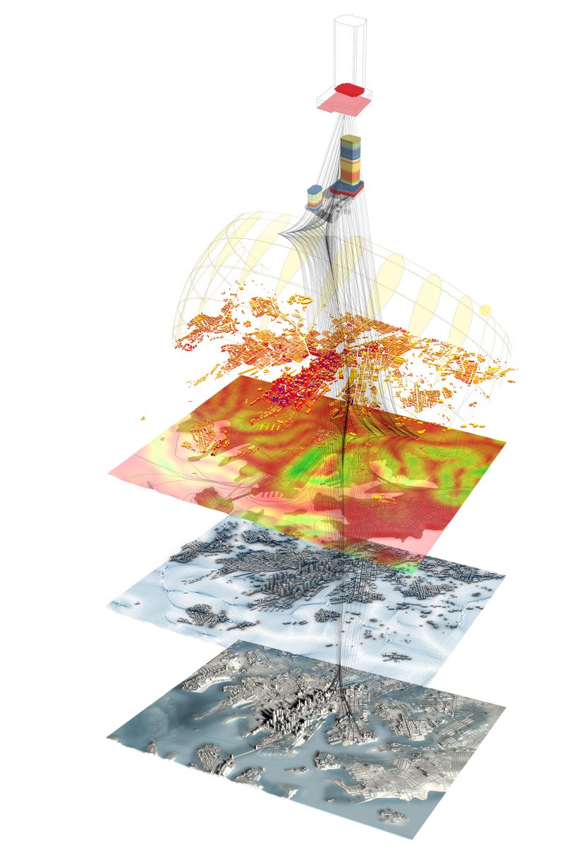
Biourbanism Lab

The ‘BioLab’ was established in response to the escalating frequency and severity of hazardous events impacting cities, regions, and communities. BioLab is our practical solution to meeting these challenges, by applying the principles of Biourbanism to real-world problems.

We process global data to generate digital solutions, geospatial intelligence, digital twins, analysis tools, bespoke project software and climate projections.


Dr Yazid Ninsalam
Talk to Dr Yazid Ninsalam about Biourbanism Lab
Get In Touch

Our Clients

Are leading decision makers who are planning the future of major global cities, revitalisation of urban centres, developments to grow thriving regional cities or custodians of significant natural environments.

They face increasingly complex and challenging problems, in diverse sectors including urbanism, infrastructure, tourism, transport, environmental sustainability, disaster mitigation or housing supply.

Each client is unique, what they have in common is they are tackling large-scale issues that require comprehensive analysis and informed solutions.

A human hand and a robotic hand are nearly touching fingers, reminiscent of Michelangelo's "The Creation of Adam." Surrounding them in the lab are translucent digital screens displaying various technological data and futuristic graphics, symbolizing the synergy of human and AI technology in biourbanism.

Data with a human perspective

The BioLab has the power to process large interlinked data sets to reveal solutions that will build resilience into every project and improve prosperity within communities.

What makes our BioLab unique is the ability to assess impacts through a human lens. Our solutions account for the diversity of human cultures, age and ability needs, and aspirations for community safety and prosperity. The ability to incorporate community engagement and behavioural data into our systems and strategies to incentivise people to interact differently with the built environment sets us apart from our competitors.

McGregor Coxall projects are underpinned by rigorous evidence-based research conducted within BioLab. This research forms the bedrock of our work across our disciplines of Climate Resilience, Landscape Architecture, and Urban Design, ensuring that our solutions are not only visionary but firmly grounded in empirical data.

A 3D illustration depicts layers of geospatial data analysis. The top layer shows a device emitting signals, reminiscent of smart home technology. The middle layers include colorful heat maps and data points, while the bottom layer represents a grayscale map with varied topography. Connections link the layers.

What is a Digital Twin?

In today’s world, data is everywhere, yet its potential remains untapped without a strategic framework to harness and organise it effectively.

We empower clients by creating robust digital twins complemented by dynamic city dashboards. The city dashboard makes the data held within the digital twin readily accessible and legible. Operating in tandem, dashboard and digital twin present a comprehensive simulation environment powered by real-world data. Users can explore and predict the consequences of design interventions and policies. Leveraging advanced technologies such as machine learning and AI, the digital twin has potential to adapt to meet evolving needs and challenges.

Furthermore, our expertise extends to geographic information systems (GIS), which serve as powerful tools for capturing, analysing, and visualising data. By overlaying diverse datasets onto maps, GIS enables stakeholders to discern patterns, relationships, and trends critical for informed decision-making.

Our Approach

Value through Research

We’re committed to continuous learning and advancing sustainable urban development through global research collaborations with universities and governments

Science Meets Design

We understand that having access to precise data is crucial for our decision-making across various fields. This approach bolsters our precision, cost-efficiency, and speed in developing sustainable communities.

Generative Optimisation

We employ generative systems to deliver solutions that streamline design optimisation and spatial analysis, blending engineering and environmental considerations into our sophisticated designs

Benchmarking Liveability

We benchmark our performance using key performance indicators and science-based metrics, enabling us to make data-driven decisions and maintain accountability in achieving our objectives.

Integrated Dashboards

Access to precise geographic and demographic data is crucial for decision-makers across fields. This approach enhances the precision, cost-efficiency, and speed in developing sustainable cities and communities.

Adaptive Resilient Environments

We’re forging impactful, climate-smart spaces rooted in their local context, utilising cutting-edge technology and data insights to ensure our designs are resilient and seamlessly integrated with the environment.

A dark globe is enveloped in glowing, interconnected lines and points, representing a network. The lines are bright orange, yellow, and blue, linking various regions with the precision of a lab experiment, suggesting digital connectivity or data transmission across the essence of biourbanism.