It goes without saying that bushfires are among the most devastating environmental disasters impacting communities across the globe. But what if we were able to predict and prevent such risk?
Through collaborative research and development between McGregor Coxall and the University of Technology Sydney (UTS), featuring our Geospatial Scientist Dr. Hossein Rizeei, Dr. Mohsen Naderpour (Centre for Advanced Modelling and Geospatial Information Systems; UTS) and Dr. Fahimeh Ramezani (Australian Artificial Intelligence Institute; UTS) an Artificial Intelligence-led framework that assesses and quantifies the probability of forest fire risk has been developed.
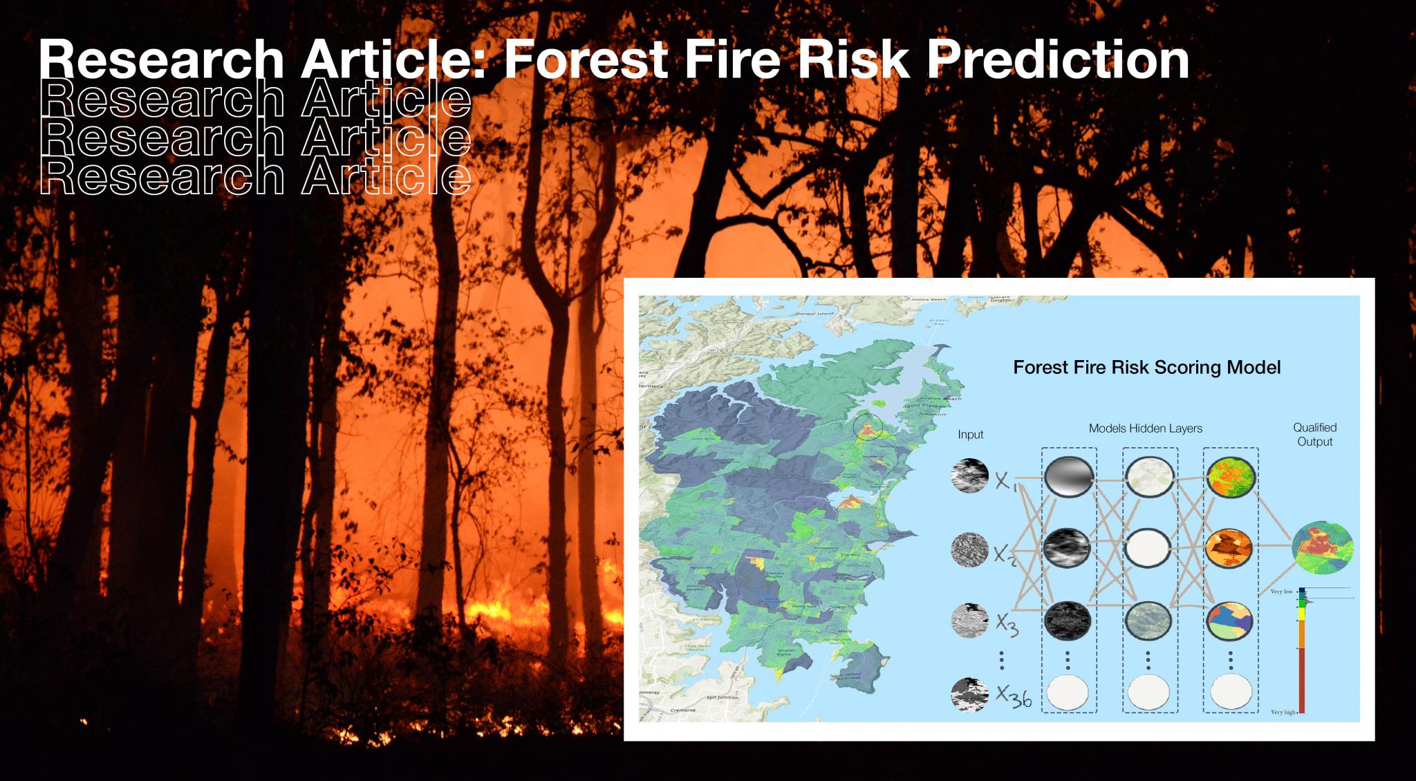
Factoring 36 indicators from topographic, climatic, and human usage elements, machine learning recognises fire occurrence patterns via an adaptable, highly-accurate predictive model – assisting environmental planners in their strategies that protect the public and conserve our rich ecological assets.
The research article was published in Remote Sensing: a prestigious, peer-reviewed, and open access journal about the science and application of remote sensing technology.
Abstract
Machine learning techniques have been recognised as well-known approaches to solving non-linearity problems such as forest fire risk. However, assessing such environmental multivariate disasters has always been challenging as modelling may be biased from multiple uncertainty sources such as the quality and quantity of input parameters, training processes, and a default setup for hyper-parameters. In this study, we propose a spatial framework to quantify the forest fire risk in the Northern Beaches area of Sydney.
Thirty-six significant key indicators contributing to forest fire risk were selected and spatially mapped from different contexts such as topography, morphology, climate, human-induced, social, and physical perspectives as input to our model. Optimized deep neural networks were developed to maximize the capability of the multilayer perceptron for forest fire susceptibility assessment. The results show high precision of developed model against accuracy assessment metrics of ROC = 95.1%, PRC = 93.8%, and k coefficient = 94.3%.
The proposed framework follows a stepwise procedure to run multiple scenarios to calculate the probability of forest risk with new input contributing parameters. This model improves adaptability and decision-making as it can be adapted to different regions of Australia with a minor localization adoption requirement of the weighting procedure.
OTHER NEWS

Insights

Insights

Insights

Media


